In most countries, an address is a given. In Côte d'Ivoire, it is an achievement. And that achievement, driven through the National Addressing Programme, is quietly transforming the way the Ivorian territory is conceived, managed and used.
Greater Abidjan
to be referenced.
Origins: why address a country?
An address is far more than a number on a door. It is the basic condition for a parcel to reach its destination, for an ambulance to find its way, for a local authority to plan its investments, for a bank to assess a risk, or for a delivery driver to optimise their route.
For a long time, Côte d'Ivoire operated without a unified addressing framework. Oral landmarks — "past the big junction, before the pharmacy, where the auntie sells doughnuts, etc." — were enough at neighbourhood level. They are no longer sufficient for an economy going digital.
To address this challenge, the Ivorian government launched the PADA: Projet d'Adressage du District d'Abidjan. The goal: to give every street, every building and every locality an official digital and physical address — geolocated and usable by all economic and institutional stakeholders in the country.
What the data reveals today
AltiaGeo-Group has consolidated and analysed all available data from the PADA for Greater Abidjan. The picture is both impressive and revealing of the challenges that remain.
What has been done:
243,943 addresses have been collected and structured within the Greater Abidjan perimeter. Behind this figure lie field surveys carried out address by address, road by road, by teams who combed through 13 municipalities.
13,755 roads have been traced and geolocated — streets, avenues, lanes and unnamed pathways forming the digital skeleton of the country's densest urban area. As we consistently point out, addressing is by far the first layer of a territory's digital structuring. This structuring also enabled the capture of 304,378 geolocated field images, providing an immersive coverage of the urban fabric rarely achieved in sub-Saharan Africa.
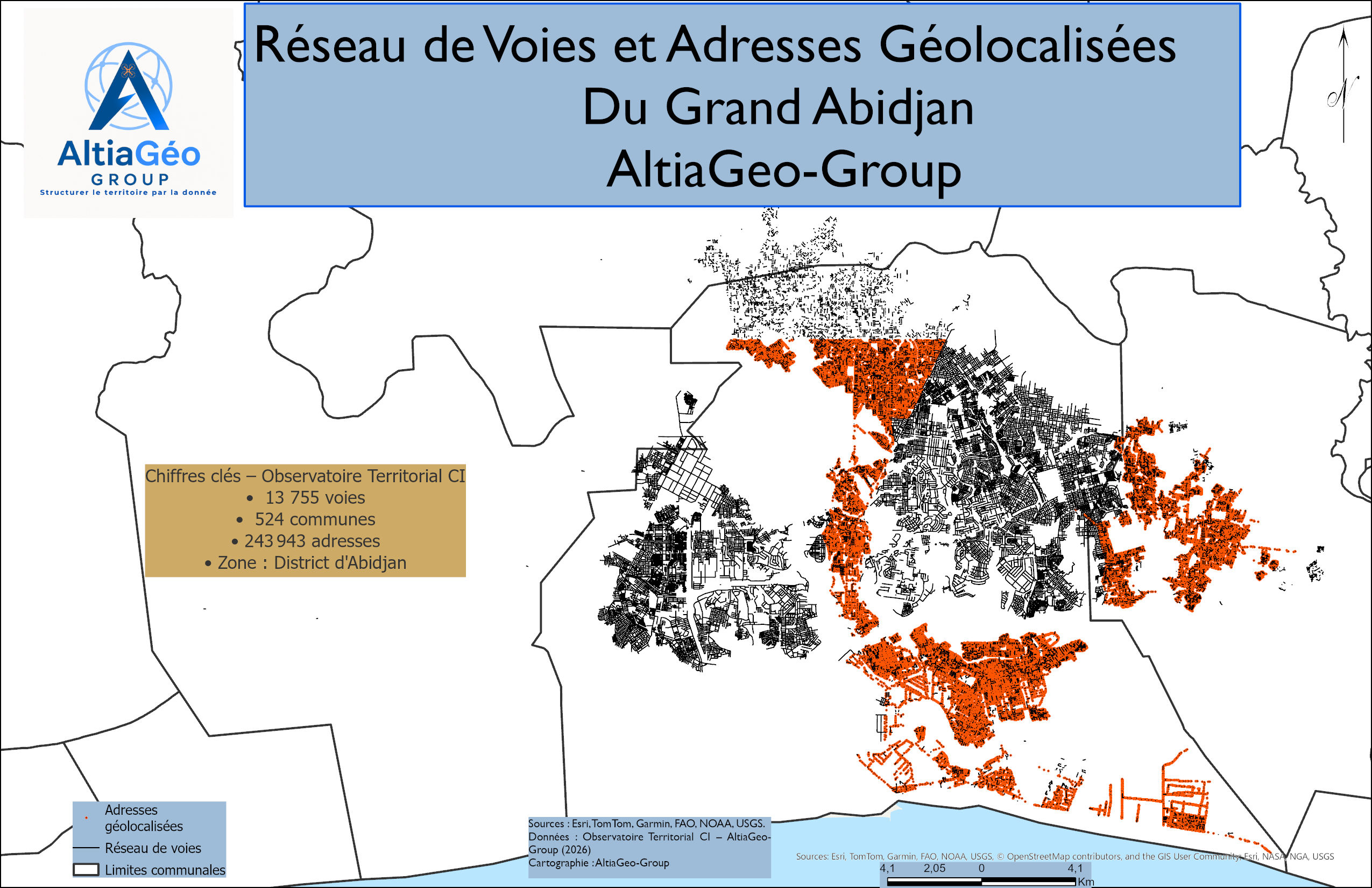
Distribution by municipality
| Municipality | Addresses | GPS rate | Status |
|---|---|---|---|
| Marcory | 12,138 | 100.0% | ✅ Complete |
| Koumassi | 15,011 | 100.0% | ✅ Complete |
| Abobo | 20,365 | 99.7% | ✅ Excellent |
| Adjamé | 9,366 | 99.2% | ✅ Excellent |
| Plateau | 1,077 | 99.0% | ✅ Excellent |
| Treichville | 5,613 | 98.8% | ✅ Excellent |
| Bingerville | 24,878 | 91.7% | ✅ Very good |
| Cocody | 82,651 | 0.1% | 🔴 In progress |
| Yopougon | 59,611 | 0.0% | 🔴 In progress |
| Attécoubé | 6,037 | 0.6% | 🔴 In progress |
| Songon | — | — | ⏳ Not available |
| Anyama | — | — | ⏳ Not available |
| Port-Bouet | — | — | ⏳ Not available |
What remains to be done:
Intellectual and analytical honesty requires saying it plainly: 150,425 addresses — over 60% of the total — do not yet have usable GPS coordinates. Three municipalities account for the bulk of this gap: Cocody (82,651), Yopougon (59,611) and Attécoubé (5,999). Three further municipalities are still awaiting field collection or have not yet been deployed.
These figures do not undermine the work accomplished. They define the next step, and highlight the scale of the potential still to be unlocked. Address data is continuously fed and kept up to date to ensure good usability.
Our reading: an under-exploited infrastructure
What we observe from our analytical vantage point is a paradox. On one side, a data infrastructure remarkable for its volume and precision, built with public resources for the benefit of the entire Ivorian economy. On the other, economic stakeholders who do not yet have access to this infrastructure in a directly usable form.
Raw data is not a tool. It becomes one when it is analysed, cross-referenced with other sources, and put to work in the service of a concrete decision — such as route optimisation, population density mapping, or identification of priority zones.
That is precisely where our role lies. While national addressing programmes remain largely driven by public authorities, AltiaGeo-Group also supports local authorities in the production, updating and valorisation of territorial data. Our approach covers the entire value chain, from structuring geographic data to transforming it into decision-support tools through spatial analyses, dashboards and territorial indicators.
Our National Territorial Observatory is the first private analytical infrastructure built on address data, with national coverage of the complete Ivorian administrative hierarchy: 14 administrative districts (based on the division preceding the 2026 reform), 31 regions, 108 departments, 524 municipalities.
Do you work with territorial data in Côte d'Ivoire?
Municipalities, institutions, logistics operators — discover how the Territorial Observatory can support your decisions.
Contact us →